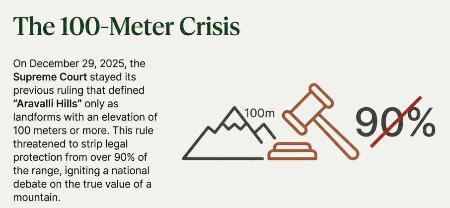
On Monday, December 29, 2025, the Supreme Court of India stayed its previous ruling that defined “Aravalli Hills” only as landforms with an elevation of 100 meters or more. This “100-meter rule” faced intense backlash because it would have stripped legal protection from over 90% of the range, potentially opening thousands of low-lying hillocks to unregulated mining and construction. The conflict lies in the dichotomy between economic extraction and ecological preservation.
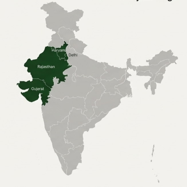
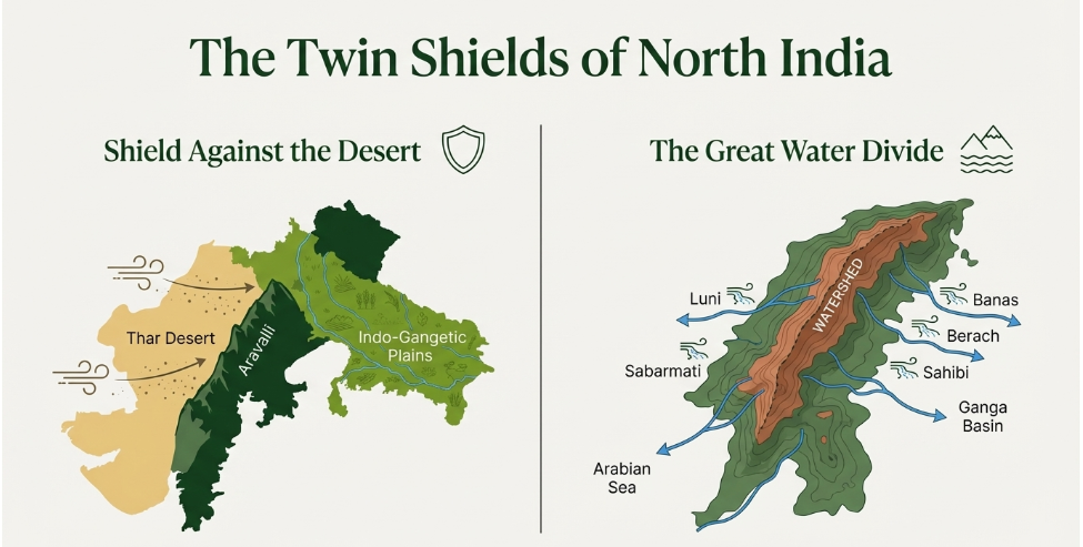
The Aravalli Range, one of the world’s oldest fold mountain systems (Precambrian era), stretches ~692 km from Gujarat to Delhi. Beyond its geological antiquity, it serves as the “Great Green Wall” of North India, acting as a vital ecotone between the expanding Thar Desert and the fertile Indo-Gangetic plains. Its fractured rocky terrain functions as a massive groundwater recharge zone, sustaining the water table for the water-stressed National Capital Region (NCR). While the range is a repository of valuable minerals (copper, zinc, silica sand), decades of “blind mining” have created 12 major gaps in the range, allowing desertification to creep toward Delhi.
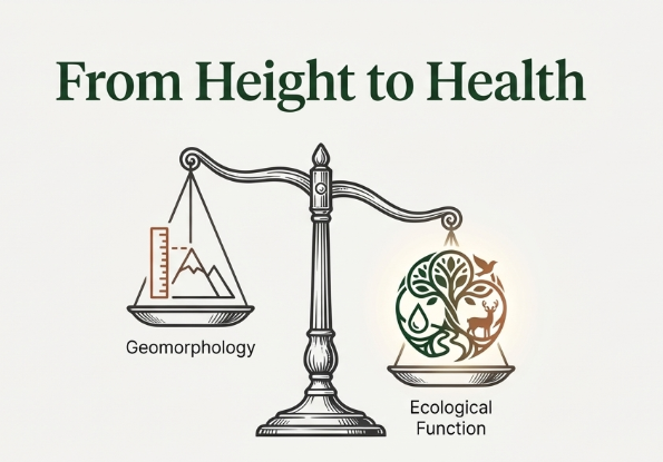
In November 2025, the Supreme Court accepted a “uniform definition” of the Aravallis based on a 100-meter elevation threshold. This meant only landforms higher than 100 meters above local relief would receive legal protection. Following widespread alarm that this would exclude nearly 90% of the hills (most are highly eroded and low-lying) and open them to mining, the Supreme Court on December 29, 2025, stayed its own ruling. The Court has now put the definition in abeyance and proposed an expert committee to revisit the criteria, prioritizing “ecological function” over mere “geomorphology.”
The Aravallis are Ancient Fold Mountains formed during the Precambrian Era (~1.8 to 2.5 billion years ago). They emerged through the Aravalli-Delhi Orogeny, a process of mountain building caused by the collision of the Bundelkhand Craton and the Marwar Craton. This makes them significantly older than the Himalayas. Originally, they were as tall as the Himalayas, featuring steep peaks and deep valleys. The lithology primarily consists of high-grade metamorphic rocks like quartzite, schists, and gneisses, which are now exposed due to the removal of overlying younger layers over eons.
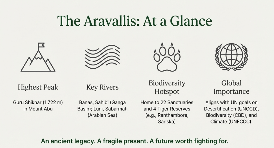
The Aravallis serve as a crucial water divide (watershed), separating India’s two major drainage systems: the Indus (to the west) and the Ganga (to the east). Rivers on the Western Slope, such as the Luni and Sabarmati, drain toward the Arabian Sea (the Luni is an inland drainage). Rivers on the Eastern Slope, including the Banas, Berach, and Sahibi, flow towards the Yamuna and eventually the Ganga. The range’s underground extension, the Delhi-Haridwar Ridge, physically separates the Indus and Ganga basins, preventing their hydrological regimes from mixing.
The Aravallis are classified as Residual Mountains (Relict Mountains). After 1.5 billion years of denudation (weathering and erosion), the once-tall peaks have been worn down to their roots, resulting in a discontinuous, hummocky topography of isolated ridges. The effects of weathering are most pronounced in the semi-arid North due to wind-blown sand abrasion. The average elevation is now 600–900 meters, with Guru Shikhar (1,722m) being the sole high point.
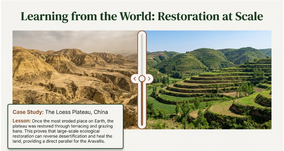
The Aravalli Green Wall Project (AGWP), inspired by Africa’s Great Green Wall, will create a 1,400 km long, 5 km wide ecological corridor from Gujarat to Delhi. Its core purpose is to be a natural barrier against the “march of the desert,” physically shielding the fertile Indo-Gangetic plains from sand-laden winds of the Thar Desert. The project involves reforesting 1.15 million hectares of degraded land to restore soil, enhance carbon sequestration, and close 12 critical “gaps” prone to desertification.
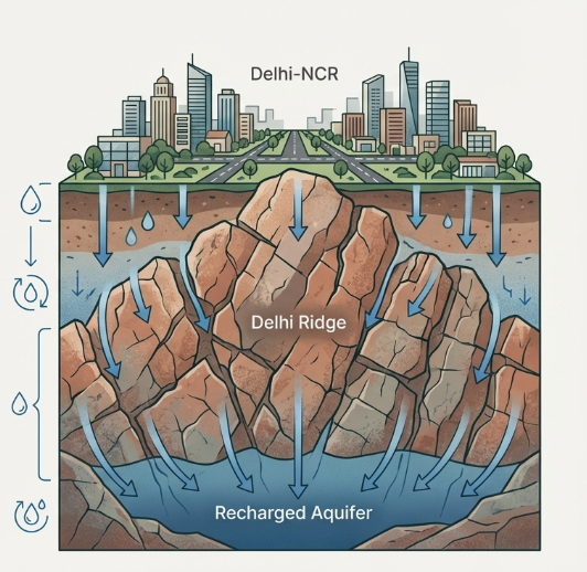
The Aravallis, made of fractured, weathered quartzite, act as a massive sponge and crucial groundwater recharge zone for the water-stressed NCR. The “Delhi Ridge” is vital for deep-seated rainwater percolation into local aquifers, mitigating the plummeting water table caused by urbanization. However, mining and construction destroy these natural fractures, reducing infiltration, increasing flash floods, and permanently jeopardizing the region’s most sustainable water security system.
A conflict arose between the Supreme Court’s November 2025 ruling (using a 100-meter elevation threshold) and the Forest (Conservation) Amendment Act, 2023, which narrowed the definition of “forests.” The SC’s height-based rule threatened to exclude 90% of the Aravalli range from protection, ignoring the broad “Dictionary Meaning” established in the T.N. Godavarman (1996) case. Consequently, the SC stayed its own ruling on December 29, 2025, opting for a “functional” ecological definition over a mere height-based one.
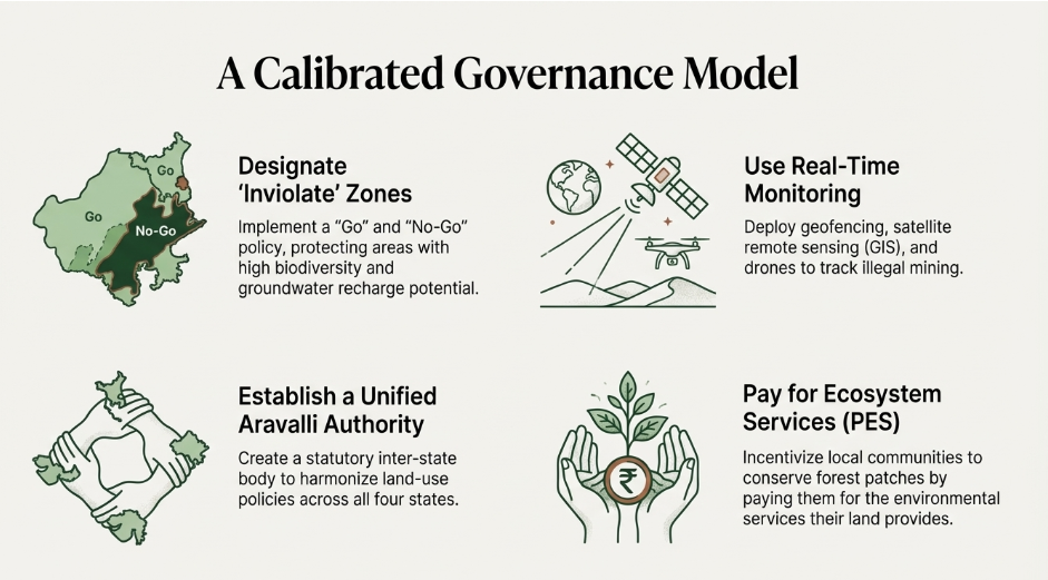
The Aravallis are a vital source of minerals, including significant reserves of non-ferrous metals (Lead, Zinc, Copper, and Silver) and critical minerals like lithium and rare earths, which the Centre deems important for national security and the energy transition. However, this resource extraction causes severe ecological damage, such as destroying wildlife corridors (like the Sariska-Delhi path), eliminating indigenous flora, and causing high levels of air pollution (PM2.5/PM10). The new Management Plan for Sustainable Mining (MPSM) aims to balance these factors by banning mining in protected “inviolate” ecological zones while allowing measured, scientific extraction elsewhere.
The Aravallis play a dual role in regional meteorology. First, they act as a topographic barrier that guides the South-West Monsoon winds toward the Indo-Gangetic plains, ensuring rainfall distribution in North India. Second, they serve as a thermal buffer. Urban areas like Delhi and Gurugram suffer from the Urban Heat Island (UHI) effect; the Aravalli forests mitigate this by providing “green lungs” that can make surrounding areas 2–3°C cooler in summer. They also obstruct hot, dust-laden “Loo” winds and sandstorms from the Thar Desert, preventing them from spiking PM10 levels in the NCR.
Despite multiple judicial bans, the Aravallis face an existential threat from the “mining mafia.” Driven by the high demand for silica sand and quartzite in the real estate sector, illegal quarrying has led to the physical disappearance of 31 hills in Rajasthan (as per 2018 reports). Enforcement often fails due to the nexus between local administrative gaps and political protection. This unregulated extraction doesn’t just lose revenue (estimated at ₹1,200 crore annually in some districts) but also creates irreversible “mining scars” that destroy the natural drainage and groundwater recharge capacity of the hills.
The legal history of the Aravallis is anchored in the M.C. Mehta vs. Union of India cases (starting 1985/2004), where the Supreme Court applied the “Precautionary Principle” to ban mining in the Delhi Ridge and Haryana. In November 2025, the SC initially accepted a 100-meter elevation rule to define “hills,” but this was widely criticized for ignoring the ecological “landscape approach.” Consequently, on December 29, 2025, the Court stayed this ruling, recognizing that a height-based definition could exclude 90% of the range from legal protection, thereby prioritizing “ecological function” over mere height.
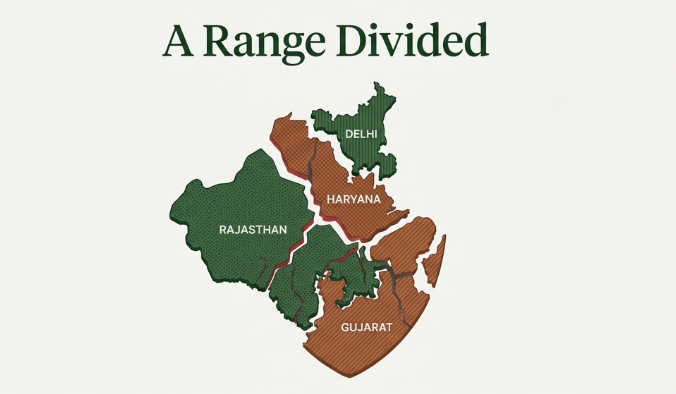
The Aravallis are spread across Delhi, Haryana, Rajasthan, and Gujarat, each having different land-use policies and “forest” definitions. This fragmented governance allows polluters and miners to exploit jurisdictional loopholes. For instance, what is a “protected forest” in one state might be “waste land” in another. There is a growing demand among environmentalists and policy experts for a Unified Aravalli Management Authority (on the lines of the National Capital Region Planning Board) to implement a standardized ecological master plan that treats the range as a single, continuous geological entity.
In the “Millennium City” of Gurugram and Faridabad, the Aravallis have become a battleground for real estate. Encroachment of lands classified as “Gair Mumkin Pahar” (uncultivable hilly land) for high-end “hill homes” and commercial infrastructure has fragmented wildlife corridors. This sprawl blocks natural “nalas” (drainage channels), leading to chronic urban flooding during monsoons. The conflict pits the lucrative construction industry against the legal mandate to protect Natural Conservation Zones (NCZs), highlighting the tension between rapid urbanization and long-term environmental sustainability.